Category: Land Surveying

Completes 3D LiDAR Survey for Anderkilla Shahi Jame Mosque in Chittagong
Land Surveying | September 10, 2024
Completes 3D LiDAR Survey for Anderkilla Shahi Jame Mosque in Chittagong

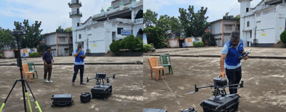
At Sthapati Associates Ltd., we are proud to announce the successful completion of a 3D LiDAR survey for the historic Anderkilla Shahi Jame Mosque in Chittagong. Utilizing cutting-edge technology, including the DJI M350 RTK drone and Zenmuse L2 LiDAR system, we captured highly accurate and detailed spatial data of this iconic structure, contributing to the preservation and study of Bangladesh’s…

LiDAR Survey Company Bangladesh
Land Surveying, Urban | August 11, 2024
LiDAR Survey Company Bangladesh

We are top LiDAR Survey Company Bangladesh. LiDAR (Light Detection and Ranging) technology is rapidly gaining traction in Bangladesh, revolutionizing the way we conduct surveys, mapping, and data analysis. This blog will explore the various applications of LiDAR in Bangladesh, from infrastructure and environmental surveys to urban planning and flood mapping. LiDAR Survey Services in Bangladesh LiDAR Survey Services in…

Land Surveying: Pioneering Precision in a Changing Landscape
Land Surveying | September 26, 2021
Land Surveying: Pioneering Precision in a Changing Landscape
Land Surveying: Pioneering Precision in a Changing Landscape Land Surveying Introduction: In the intricate tapestry of urban development and construction, one profession stands as the bedrock – land surveying. Often overlooked but undeniably crucial, land surveyors are the architects of precision, shaping the way we define, plan, and build on the Earth's surface. This blog embarks on a journey to...